Posts

The Houses on Stilts: Tawi-Tawi

Image
We decided to head back to Bongao, and pass some more spots that we could along the way. We actually took a path that encircled Bud Bongao. There were a lot of green on one side, and to the other, blue all the way. Of course, Tawi-Tawi won't look the same without the houses on stilts built by the Tausugs and the Badjaos. Tawi-Tawi is also known to be an area for migrants from Malaysia and Indonesia, though I heard most of them are not happy that they are here. Nevertheless, they put up residence on bamboo stilts on the shallow white sand beaches along the coast. Some of the areas we passed by were entire communities that looked like a village on stilts. Some houses were abandoned though. Some even had the flags of their tribes on poles. The sun was setting on the other side of Bud Bongao, though some of the rays pierced through to give us a dramatic setting. We found a sand bar that stretched to sea for around 200 meters. Yes, that was long, and it gave us a very nice vantage point...

White Sands in Tawi-Tawi

Image
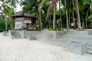
Landing in Tawi-Tawi was a dream. I never thought that this would be the year that I would be going to the Southern most province of the country. Hence, I didn't make any plans. I only have one night here, so I wanted to make the most out of the trip. Of course, that would mean hitting the beach. After the frustrating no-beach experience in Sulu, I made sure I would be stopping by to get some sand on my feet. After all, I knew Tawi-Tawi was safe, and the people were nodding their heads when I kept asking if we could go to the beach. So, after work, we headed straight to the store, bought some beer and chips, and made out way South of town. Actually, there would be no problem looking for a beach here, since they're everywhere on the coast. We passed by a coastal road that had a lot of white coral beaches, but most of them had houses on stilts. So we moved further away from town to find a secluded spot. And this is where we ended up in. Coconut trees were swaying to the gentle br...

Landing on Bongao, Tawi-Tawi

Image
From Jolo, we went back to Zamboanga to catch another Sea Air flight to our next exotic destination, southern most province of the country, Tawi-Tawi. We already felt we had a private plane to ourselves, since we always rode the same plane. The view from above was not as clear, and the flight was deafening and longer. It took us 1 and a half hours from Zamboanga to Bongao, the capital of Tawi-Tawi. As soon as I saw Bud Bongao, the highest peak in these islands, I was having headaches from the sudden descent. Our pilot had to go around again and take another chance in landing the small aircraft. So we landed safely, and awaited for our gracious hosts. I immediately sensed Tawi-Tawi was going to be different from Sulu. We had no police escorts, and the presence of the military dwindled. We rode a red multicab and drove off to the center of Bongao town, passing by the coastline and going around Bud Bongao. We arrived in our hotel, Rachel's Place, which is one of the 4 accommodations i...

The Unforgettable Trip to Jolo, Sulu

Image
When I heard that I was going to Sulu for a shoot, I almost fell off my chair in excitement. Despite all the warnings and numerous prevention measures by my friends, I was able to hop on a plane to Zamboanga City, for my Sea Air flight enroute to Jolo, the capital of Sulu. I expected Sulu to be beautiful, after hearing all the nice places there from people who have been there. We were descending already when I saw these island patches and long sandbars, with houses on stilts. I have never seen anything like that. Well, if there were inhabitants there, then there must be a way of going there. We landed at the airport, which was bombed a week before we arrived. The runway was being constructed, so we had to board a jeep to take us to the terminal. I must say, the military presence and feel of the place scared me a bit. And after hearing the news about the recent bombing, I really felt uneasy. But, excitement still won me over, and I hastily jumped into our jeepney service that was follow...

Mermaid Dreams in Magpopongco

Image
An hour away from General Luna by motorbike is Pillar town. Located near the northeastern coast of Siargao, Pillar is not known to many people. Not even our resort manager, Babu, knew what was good there. But I saw a picture in the internet about a certain beach, which had natural coral pools that formed during the low tide. Without hesitation, and with a thirst for adventure, I immediately asked Babu to take me there. Welcome to Magpopongco. This was the beach that greeted me when I arrived in Magpopongco. It is the top attraction of Pillar town, and is the venue of the International Game Fishing Tournament. President GMA already visited the place last May for the international competition. Hence, the local DOT has developed the place. I had a nice chat over bottles of beer with the tourism official there. Well, the beach is actually not the attraction. Though wide and sandy, it is what lies beyond the rocks that has left each visitor mesmerized. A concrete walkway was constructed lea...

Cool Cloud 9

Image
Cloud 9 is the place that comes into mind when you speak of Siargao. This world renowned surfing spot has actually been a destination for surfers for several years. It's just recently (well, in the last 5 years) that Cloud 9 was elevated to the world stage after being featured in several magazines. It is the Philippine's premier surfing spot. Getting to Siargao is an adventure, not until recently when Cebu Pacific opened direct flights to the island from Cebu. Now, most surfers go directly to Cebu and then catch a flight to Siargao. Cliud 9 is around 4 km from the center of General Luna. You cannot really walk to Cloud 9, but you can in 30 minutes I guess. Most people rent motorbikes, or stay in the Cloud 9 area. There are several resorts there, from simple bungalows to luxurious resorts. There is a wooden boardwalk that leads to the surf. There is also a platform at the end, used by judges during competitions. The boardwalk looks rickety, but is actually sturdy, considering th...

Guyam Island

Image
Imagine, this island was just in front of Patrick's on the Beach. It was around 10 minutes away via boat. Though the seas were rough, I made it a point to convince Babu, the resort manager, to take me there. He first told me that I could kayak my way there, but after seeing the waves, he was generous enough to take me there (P500 roundtrip on a big boat). The island was called Guyam. Guyam reminded me of Waniban Island in Mati, though it was much more picturesque. The sand was blinding white, though a bit grainy (not Boracay sand for those who always ask me). The tide was low, so a lot of sand was exposed. The island is surrounded 50% with a sandy beach. The rest was lined with battered rocks facing the raging Pacific. The wind blew hard that day, so the palm trees were dancing. The sun was up though when I docked, so it made my stay more pleasant. There were huts in the center of the island, and no inhabitants. The huts were set-up by the resort owners of General Luna. I heard tha...